Depression in Arabian Sea may bring rains in Tamil Nadu

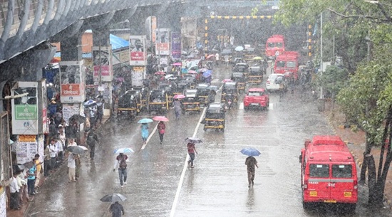
Cyclone Madi after 8 days of moving northwards and back over the Bay of Bengal finally made landfall as depression at Thondi in Ramanat�hapuram at 10.30 pm on Thursday. The depression earlier crossed land near Vedaranyam at 7 pm on Thursday before moving into the Palk Strait and entering land again. The weakened system later moved into Kerala and entered the Arabian Sea on Friday morning.
The unique inverted �V� system brought good rainfall to the coastal districts of Tamil Nadu on Thur�sday. For the 24-hour period ended 8.30 am on Friday, Colachel in Kanyakumari district, Tindi�vanam and Kallak�urichi in Villup�uram district, Eraniel in Kanyak�umari district and Cheyy�ur in Kanc�heepuram district, recorded the highest rainfall in the state at 11 cm each. Ulundurpet in Villup�uram district and Virudhunagar recorded 9 cm rainfall each, followed by Attur in Salem district (8 cm). Tirumangalam and Madurai airport in Mad�urai district and Villup�uram registered 7 cm each. In the city, Nung�amba�kkam (0.9 cm) and Meenambakkam (0.01) recorded less than 1 cm rainfall.
Met officials say that scattered rainfall is expected in the state for the next few days. �There are chances for rain in south TN due to some trough movements,� said S.R. Ramanan, director, Area Cyclone Warning Centre, Indian Meteorological Depart�me�nt, Ch�ennai.
Top Stories
-
 Tamil Nadu Weather Update: Heavy Rain Forecast for 7 Districts27/Jun/2026 3:35:40 PM
 -
 Sell Gold Safely in Chennai: What Every Seller Should Know27/Jun/2026 2:51:21 PM
 -
 KADHAIPOMA Lite Edition to Bring People Together in Chennai on June 2827/Jun/2026 2:15:46 PM
 -
 Southern Railway Achieves Highest Passenger Occupancy on Special Trains in FY 2025-2627/Jun/2026 2:11:53 PM
 -
 Chennai Corporation Plans Landmark Public Plaza Near Omandurar Government Estate27/Jun/2026 1:41:08 PM
 -