No. of views : (7223)
Chennai mapped with 306 flood-prone zones
Posted on: 04/Aug/2018 11:57:03 AM
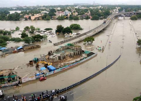

Tamil Nadu State Disaster Management Authority mapped the possible flood prone zones of Chennai. The detailed analysis was the result of the devastating effect of December 2015 floods in Chennai. With this study the civic body determined 859 locations affected by the floods out of 15 zones. After jotting down the researched categories 306 areas are classified as flood-prone areas. Among this 37 areas are considered to be high vulnerable zones for more careful protective measures during the monsoon rains.
Areas prone to submerge more than 5 feet of water are classified as very high vulnerable flood prone zones while the areas with 3 feet level of water retention tagged as highly vulnerable. Other than the two classifications there are medium and low vulnerable flood prone zones grouped all together in 306 areas.
Initially 859 areas were found out to be more vulnerable for high levels of water retention in the floods. After several draining system projects and rectification of the infrastructure, TNSDMA finalized the 3016 flood prone areas in Chennai. Adyar and Cooum banks has some of the highly vulnerable flood prone zones like Velachery, Guindy, Thiruvanmyur and Saidapet. Teynapmet zone covers the areas of Nungambakkam, Thousand lights, Alwarpet, Mylapore, Santhome, Chepauk, Royapetah, RA Puram and Triplicane. Valasaravakkam has 26 flood prone areas and surrounding localities near Chembarambakkam Lake, Porur, Pallavaram and Chrompet are all classified in the final list for the state authorities to take possible protective measures during the monsoon.
Post your requirement - We will connect with the right vendor or service provider