Cyclone Madi-Latest update

The development of the low pressure in the Bay of Bengal is very keenly watched by the weathermen.
It first appeared as a cyclonic circulation on the 1st of December and remained as a well-marked low for 5 days. The system turned into a depression and then a deep depression last night and as predicted earlier, it became a cyclone on the 7th morning.
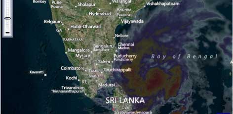
Cyclone Madi, designated by Maldives according to the tropical cyclone naming protocol applicable for North Indian Ocean, has the potential of strengthening into a severe cyclonic storm within 36 hours. This slow moving system is showing a northward shift and is presently stationed at 10.5� N and 84� E latitudes, which is about 400 km away from Chennai. Cyclone Madi will travel as a cyclone with wind speeds of 60 to 70 kmph, gusting to about 85 kmph, for the next two days.
The cyclonic storm is likely to strengthen further bearing strong winds of around 80 to 90 kmph, gusting at 100 kmph. Later, on turning into a severe cyclone, winds will be in the tune of 120 kmph. The system will remain at sea, well away from the Indian coast for another two days. However, it may weaken before making landfall near Myanmar or Bangladesh. Fortunately for India, Cyclone Madi will not pose any threat to the Indian coast. In view of this system, south coastal Tamil Nadu received good amounts of rain this week. However, no rain was recorded in the last 24 hours, except for traces in Chennai.