Latest on Cyclone Burevi: Heavy rains in south TN from today 3rd December!
The impact of the cyclonic storm �Burevi� is expected to be maximum pact on south Tamil Nadu coastal districts from today noon (Wednesday, 3rd December).
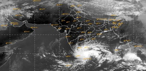
The cyclone Burevi has crossed the Sri Lankan coast. It has moved nearly west-northwestwards, to emerge into the Gulf of Mannar and adjoining Comorin area.
The Cyclonic Storm, with a wind speed of 70-80 gusting to 90 kmph, would be centred very close to Pamban by today noon (3rd December).
Cyclone Burevi will then move west-southwestwards across Pamban and cross south Tamil Nadu coast between Pamban and Kanyakumari tonight and on Friday early morning (4th December) as a cyclonic storm with a wind speed of 70-80 gusting to 90 kmph.
As such, its impact is likely to commence from forenoon initially over Ramanathapuram district and gradually towards Kanyakumari district.
The Chennai Regional Meteorological Centre has informed that there are prospects for heavy rain at isolated places over the districts of Ramanathapuram, Sivagangai, Thoothukkudi, Tirunelveli, Thenkasi and Kanyakumari and heavy to very heavy rain at isolated places over the districts of Pudhukkottai, Thanjavur, Thiruvarur, Nagappattinam, Villupuram, Cuddalore, Mayiladuthurai and Puducherry, Karaikkal area and Kerala.
Heavy rain is also likely to occur at isolated places in the districts of Kanchipuram and Chengalpattu districts.
The sea conditions would be rough to very rough and fishermen were advised not to venture into the sea for the next three days.
It is expected that the storm would cause damage to thatched huts, minor damage to power and communication lines due to the breaking of branches, major damage to �kutcha� and minor damage to �pucca� roads, besides some damage to paddy crops, banana, papaya trees and orchards.
Top Stories
-
 Are You Using Your Credit Card Rewards the Right Way? Tips to Get More Value25/Jun/2026 3:52:09 PM
 -

-
 Start Your Own Matrimony Business with a Powerful Online Platform25/Jun/2026 3:17:59 PM
 -
 Tambaram - Velachery Road Renamed as Major Mukund Varadarajan Road25/Jun/2026 3:10:13 PM
 -
 Income Tax Return Deadline Extension Unlikely in 2026; Taxpayers Advised to File Early25/Jun/2026 3:02:01 PM
 -