Chennai and North Tamil Nadu to Experience On-and-Off Rains Today, Delta District Sees Relief
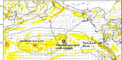

A low-pressure area moving close to Puducherry is set to merge with the trough today, according to the latest weather updates. Radar imagery shows clouds shifting from the Cuddalore–Puducherry belt towards Chennai, bringing intermittent rainfall to the region.
Rain Forecast
Chennai (KTCC) and Ranipet: On-and-off rains expected throughout the day, with breaks in between. Heavy rainfall is currently observed in North Chennai suburbs, which will continue for the next hour before moving towards Minjur, Ponneri, and Gummidipoondi belts.
Delta Districts (Nagapattinam, Tiruvarur, Thanjavur, Cuddalore, Puducherry): Rainfall is reducing, with only isolated spells expected. Winds will shift from easterlies to southern direction.
Areas to Watch
Tiruvallur District: Heavy rainfall expected today with intermittent breaks.
Kanyakumari District: Likely to experience heavy rainfall due to pull effects from the northern low-pressure system.
Kodiyakari: Tip of the region may see rainfall from southern clouds as the northern low exerts influence.
Meteorologists have advised residents to thank the current low-pressure system for the one-day heavy rains, which is merging with the trough extending from the Arabian Sea.
Upcoming Weather
The next low-pressure area is expected to form around October 25, which will be closely tracked for further rainfall activity across Tamil Nadu.
Source: Tamil Nadu Weatherman