Cyclone Mikjam Intensifies, Expected to Make Landfall Between Nellore and Masulipatnam
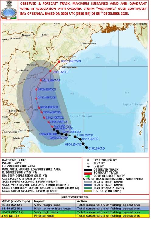
In a significant development, the deep depression over the Southwest Bay of Bengal has intensified into Cyclonic Storm Mikjam, posing a potential threat to the coastal regions. As of 0530 hrs IST on December 3rd, the cyclonic storm is situated about 300 km east-southeast of Puducherry, 310 km southeast of Chennai, 440 km southeast of Nellore, and 550 km south-southeast of Machilipatnam.
Widespread Northeast Monsoon rains are currently impacting Tamil Nadu, with heavy rainfall particularly affecting north coastal districts, including Chennai. The intensification of the severe depression into Cyclone Mikjam adds to the weather challenges faced by the region. The storm, currently 310 km from Chennai, is moving at a speed of 5 kmph in a southeast direction. The Meteorological Department predicts that it will shift in a northwesterly direction, gaining strength as it heads towards North Tamil Nadu.
Cyclone Mikjam is anticipated to make landfall between Nellore and Masulipatnam on the evening of December 5th, according to the India Meteorological Department. The affected areas, spanning approximately 90 to 100 km, are expected to experience winds reaching up to 100 km/h. Consequently, heavy rainfall is predicted in various locations across Tamil Nadu, Delta districts, and some interior areas today and tomorrow.
Local authorities and residents are urged to stay vigilant and take necessary precautions in light of the impending cyclonic conditions. The evolving situation will continue to be closely monitored by meteorological agencies, with updates provided to ensure public safety.
Top Stories
-
 Tomorrow Panchangam June 20 2026 | Auspicious Timings, Rahu Kalam, Gulikai19/Jun/2026 5:33:50 PM
 -

-
 Roblox Kids and Roblox Select accounts launched worldwide now available in India19/Jun/2026 5:28:38 PM
 -

-
-
 TN TET 2026 Hall Ticket Released: Paper I & Paper II Admit Cards Available for Download19/Jun/2026 5:19:47 PM