Cyclone Burevi weakens into deep depression now
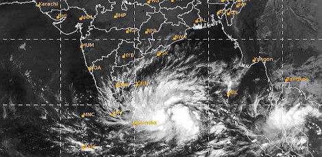
On Thursday evening, the cyclone Burevi has weakened into a deep depression. This cyclone that moved at 9kmph over Gulf of Mannar close to Pamban is known. This has resulted in widespread rains in the state of TN. After crossing Ramanathapuram and Tuticorin, the system would further weaken into depression on Friday morning. This was as per the officials belonging to IMD.
It was later revealed by Mr. S. Balachandran, director, Area Cyclone Warning Centre, RMC, Chennai that the cyclone Burevi weakened into a deep depression and as on 5:30 pm Thursday it lay centred over Gulf of Mannar about 20km southwest of Pamban, 210km east northeast of Kanniyakumari. He added that it would move west south westwards and cross Ramanathapuram and Tuticorin districts during 3rd December night to early hours of 4th December. In the subsequent 12 hours of time, it would weaken into a depression.
It must be taken into account that when the system weakens the speeds of the winds could also reduce from 55kmph- 65kmph (gusting to 75kmph) to 50 kmph -60 kmph (gusting to 70kmph) and this would occur when it crosses the coast.
By Friday morning, it is expected to reduce to further 40kmph -50 kmph gusting to 60kmph. Burevi remained stationary for several hours when it moved over the Gulf of Mannar near Pamban early in the day.
The opposing winds from the west were responsible for this and these pushed the system westwards. This was mentioned by some weather experts. There was heavy rainfall in the southern coastal districts like Kanniyakumari, Nagapattinam etc plus many central districts like Ariyalur, Thanjavur and Thiruvarur etc got heavy rains plus thunderstorms. Throughout the day, many northern districts like Chennai, Kancheepuram, Tiruvallur, Chengalpet, Villupuram, Thiruvannamalai etc received moderate rains.
Mr. S. Balachandran then shed light on the convective cloud bands that moved to central parts of TN due to the system`s interaction with the land. According to an official belonging to IMD
It was clear that in the next 24 hours widespread rainfall is likely to occur in TN and there would be heavy to very heavy rainfall over south TN and Gulf of Mannar. Throughout Thursday, most parts of TN were soaked in the rains and this led to normal lives getting affected in southern and in the central districts of TN. The rains have even led to few losing their lives due to the electric shocks etc.
Point is in Ramanathapuram district, many were shifted to the relief camps. Information is that in Madurai and in Trichy districts rain water inundated many low lying areas. It is important to mention that Madurai experienced one of the wettest days in the recent times due to 13.27mm of average rainfall in the last 24 hours.
Till 8am in the morning, Ramanathapuram receceived 120 mm of rainfall and in the next 8 hours it received 61.40mm rains. Truth is that the sea remained rough in places like Rameswaram and in Pamban. Until Friday night in Coimbatore and in the Nilgiris, wet weather would be there.
Top Stories
-

-
 India’s Gold Demand Rises 10%: Sharp Surge in Investment Buying, Jewellery Demand Falls!!25/Jun/2026 12:26:50 PM
 -
 The Best Investment for Business Growth Is Continuous Learning25/Jun/2026 12:21:26 PM
 -
 Rural Gold Jewellery Demand Falls 19% as High Prices Keep Buyers Away25/Jun/2026 12:21:13 PM
 -
 ITR Filing AY 2026-27: Key Changes and Important Checks for Taxpayers25/Jun/2026 12:04:47 PM
 -
 12 Powerful ChatGPT Tips Every User Should Know in 202625/Jun/2026 11:59:51 AM