POTENTIAL CYCLONE FANI TO FORM SOON IN BAY OF BENGAL
Season�s first cyclonic storm is on way and is most likely to make an appearance in Bay of Bengal by the early next week. There is a long journey that lies ahead of the brewing system that would actually decide the course of the likely tropical storm. Let us a have detailed look on the various aspects of this potential storm.
First and foremost, if this system strengthens into a cyclonic storm, it would be named as �Fani� and would be the maiden storm of the year for India as well as Bay of Bengal.
Journey :
At present, the system is at a nascent stage and is seen as mere cyclonic circulation over extreme Southeast Bay of Bengal and adjoining Equatorial Indian Ocean.
According to weathermen, models are indicating that the system would be initially moving in northwest direction. It is likely to get more marked during the next 24 hours and would be inducing a low pressure area by April 25. By then, the system would have moved over southeast and adjoining Southwest Bay of Bengal and nearby areas of Indian Ocean.
Moving forward, by April 26, the system would further intensify into a depression and move over Southwest Bay of Bengal and adjoining Indian Ocean. Favourable atmospheric conditions would be further enhancing the strength of the depression. This may turn into a deep depression and finally into a tropical storm in the subsequent three days i.e. April 29.
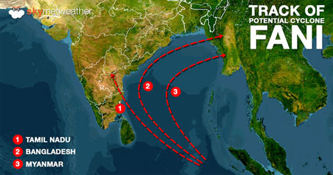
Track :
Though it is too early to talk about the track of the likely storm, but we can see that there is no consensus among the numerical weather models. While some are indicating that the storm would be heading towards Indian coast of Tamil Nadu in close proximity to Chennai, others are pointing towards re-curving of the system towards Myanmar and Bangladesh.
Nonetheless, in both the scenarios, Tamil Nadu and Chennai would see rains and thundershowers but of varying in intensity. Scenario 1 would give some torrential rains over Tamil Nadu including Chennai but in scenario 2, the state would see light to moderate rains only.
Although majority of numerical weather systems are in favour of the former than the latter. But, since we have six days in between, we need to wait and watch. The picture would be cleaner by the end of the week.
Intensity:
The brewing system has a great potential of intensifying into a cyclonic storm. However, despite all favourable conditions, we are afraid that as of now it doesn�t seem to be a very strong tropical storm.
The reason behind this that the potential storm is traveling in lower latitudes, very close to the equator. Going by the rules, the proximity of equator would not let it grow much in terms of intensity.
Courtesy : skymetweather.com
Top Stories
-
-
 Tomorrow Panchangam June 27 2026 | Auspicious Timings, Rahu Kalam, Gulikai26/Jun/2026 5:51:10 PM
 -
 ChatGPT Tip: Compare Products Smarter Before You Buy26/Jun/2026 5:37:31 PM
 -

-

-
 Discover the Vibrant Flavours of Thailand at Sian, Vivanta Chennai, IT Expressway26/Jun/2026 5:23:44 PM