Cyclone Ockhi forms, severe cyclonic storm likely in 24 hrs
As predicted, the deep depression over Comorin area has intensified further into Cyclone Ockhi by the noon of Thursday. This is the maiden tropical storm of the season to develop in any of the Indian Sea.
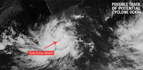
Moving at a speed of 38 kmph, the system is tracking west�northwestwards. It is centered at Latitude 7.5�N and Longitude 77.5�E, around 55 km south of Kanyakumari, 120 km southwest of Thiruvananthapuram, 480 km east�southeast of Minicoy and 340 km west�northwest of Galle in Sri Lanka.
According to Skymet Weather, the cyclone would continue to move west�northwestwards towards Lakshadweep Islands. Weather conditions remains conducive for the further strengthening of the system into a severe cyclonic storm in the next 24 hours.
At present, the system is traveling in warm waters as sea surface temperatures are very warm to the tune of 30�C. Besides this, vertical wind shear is also low. Both the factors will keep the conditions conducive for further intensification of the system into a severe cyclonic storm, said Mahesh Palawat, VP-Meteorology, Skymet Weather.
This system will trigger high velocity winds with the speed ranging from 65-75 kmph gusting to 85 kmph along and off South Kerala and South Tamil Nadu during the next 48 hours and 24 hours, respectively.
Meanwhile, Lakshadweep would witness squally winds with the speed of 55-65 kmph gusting to 75 kmph during next 12 hours. Speed of winds is most likely to increase to 80-90 kmph gusting to 100 kmph from Thursday night as the system nears the island.
Heavy to very heavy rains are expected to lash southern parts of Kerala and Tamil Nadu. In fact, weathermen are predicting some torrential rains with damage potential over Alappuzha, Kottayam, Idukki, Kollam, Pathanathitta, Thiruvananthapuram, Kanyakumari, Tutukudi and Tirunelveli.
Heavy rains with squally wind are already being reported from these areas. With more rains in offing power outrage, snapping of communication lines, uprooting of trees cannot be ruled out.
The first tropical storm of the season is finally on its way. According to Skymet Weather, the depression over Sri Lanka further intensified into a Deep Depression in the wee hours of Thursday morning.
Moving west�southwestwards, the system is seen over Comorin region and nearby areas and is presently centered at latitude 6.7�N and Longitude 78.3�E, around 170 Km southeast of Kanyakumari and 240 km west�northwest of Galle in Sri Lanka.
Cloud configuration and atmospheric conditions are indicating towards the further strengthening of the deep depression into a cyclonic storm by Thursday evening. The cyclone would be named as �Ockhi�, which would be the first tropical storm of the season to develop in Arabian Sea.
According to weathermen, the weather system is presently travelling in favourable weather conditions into warm sea surface temperatures with abundant moisture. Weather models are predicting that chances of cyclonic storm intensifying into a severe cyclonic storm also cannot be ruled out, with long sea travel ahead.
Currently, potential cyclone is moving in west-northwest direction towards Southeast Arabian Sea. With this, intensity of rains will be extremely heavy over r southern tip of peninsular region that would include Kerala and South Tamil Nadu.
Places like Kanyakumari, Cuddalore, Sriviakuntam, Tutticorrin, Rameshwaram, Ramanathapuram, Tondi, Nagercoil, Kovilpatti, Pamban, Thiruvananthapuram, Alappuzha, Kollam, Kochi, and Kottayam may see torrential rains during the next 24 hours. Chennai may also see on and off moderate rain with few heavy spells on Thursday.
Sea will be rough to very rough off and along the coast of Kerala and South Tamil Nadu for another 48 hours. Fishermen and locals are advised not to venture out in the sea during the time.
After reaching Southeast Arabian Sea, cyclone is most likely to move in northwest direction towards west central Arabian Sea. With the system moving away, rains would reduce gradually over Tamil Nadu after 24 hours and over Kerala after 48 hours.
Courtesy: skymetweather.com
Top Stories
-
 JB SOFT SYSTEM Helps Organizations Build Powerful Community Portals22/Jun/2026 5:25:45 PM
 -
 Tomorrow Panchangam June 23 2026 | Auspicious Timings, Rahu Kalam, Gulikai22/Jun/2026 5:20:37 PM
 -
 What is Contractor’s Plant & Machinery Insurance22/Jun/2026 5:17:09 PM
 -
 Transparency Emerging as Key Factor in Chennai Joint Venture Projects22/Jun/2026 4:52:49 PM
 -
 Heavy Rain Likely in 7 Tamil Nadu Districts Today; Chennai Rains Expected from June 2522/Jun/2026 3:55:46 PM
 -
 Chennai Metro Vadapalani–Poonamallee Line to Open in July, Travel Time Reduced to 30 Minutes22/Jun/2026 3:51:24 PM