No. of views : (4806)
Prospects for medium rains in a few places due to low-pressure zone!
Posted on: 12/Oct/2020 11:50:11 AM

The Chennai Regional Meteorological Centre has informed that there are prospects for mild rain with thunder in a few places today (Monday, 12th October) in North Tamil Nadu due to the low-pressure zone prevailing over the central-east Bay of Bengal.
In this regard, an official from Chennai Regional Meteorological Centre informed:
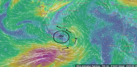
A strong depression zone was prevailing on Saturday (10th October) over the central-east Bay of Bengal and the adjacent southeast Bay of Bengal. This depression zone has now intensified further and transformed into a severe depression zone on Sunday.
On Sunday (11th October) afternoon, this depression zone had stabilized over the central-west Bay of Bengal at 370 km distance from Visakhapattinam. In the nxt 24 hours, it may intensify to transform into a very severe depression zone. It may drift towards west, northwest and may cross the North Andhra Coast by tonight (Monday, 12th October).
Due to this, there are prospects for mild to medium rains with thunder in a few places in North Tamil Nadu and mid rain with thunder in a few paces in other districts.
As regards the Chennai Metro City and its suburbs, the sky will remain generally cloudy. There are prospects for mild to medium rains in a few parts of the city.
Recorded rainfalls
As at 8.30 AM on Sunday (11th October) morning over the last 24 hours, the recorded rainfall in mm in various places: Panjappatti, Karur district � 90, Thirukkazhukkundram, Chingleput district, Pallippattu, Thiruvallur district, Thiruchuzhi, Virudhunagar district � 50 each, Arur, Dharmapuri district, Aalangayam, Thirupathur district, Utharamedlur, Kanchipuram District � 40 each, Thenkanikkottai, Krishnagiri District, Polur, Thiruvannamalai district, Perunthurai, Erode district, Vathalai, Trichy district, Kamatfchipuram, Dindigul district, Kunnur, Nilgiri district, Manamadurai, Sivagangai district, and Palavidudhi, Karur District � 30 each.
Warning for fishermen: Due to the depression zone prevailing over the Bay of Bengal, high speed winds at 45 kmph to 55 kmph may blow across in the areas of Kanyakumari Ocean, Mannar Bay, and Andaman Sea. So, the fishermen are WARNED NOT TO VENTURE INTO THE SEA UNTIL 15TH OCTOBER.
Further, the fishermen in the central-west, northwest, Southwest Bay of Bengal and the coastal areas of Andhra and Odisha are WARNED NOT TO VENTURE INTO THE SEA ON MONDAY, 12TH OCTOBER (today).
High Waves:
In the South Tamil Nadu coastal areas from Kulachal to Dhanushkodi, sea waves of 3 metres to 3.7 metres would occur until 11.30 PM on 12th October (today)In the North Tamil Nadu coastal areas, the sea wawaves of 3 metres to 3.3 metres height would occur from Kodiyakkarai to Pulikkaadu.
Post your requirement - We will connect with the right vendor or service provider