No. of views : (8600)
Tamil Nadu Weatherman Special Update
Posted on: 11/Nov/2017 3:45:55 PM

Kindly note this is not an official forecast. Please follow the official forecast by IMD. I have posted lots of charts with explanation. This could be useful for people to learn, if they are interested.
Normally a typical active spell of monsoon associated with low pressure and will last 3-4 days. Last low pressure gave rains for 9 days. Then for past 3 days we had break in rains.
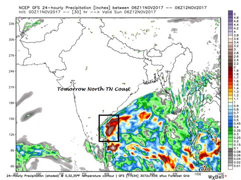
2nd low pressure after NEM setting in - North TN coast from Nagai to Chennai will get most of the rains.
----------------------------
Now the 2nd Low Pressure lies in SW bay and this is a broad low means very big in size and not too concentrated. So the clouds are spread over large area. And remember when the low is located in SW bay it always benefits the north TN coast (Tiruvallur, Chennai, Kancheepuram, Cuddalore, Pondy, Nagai and Thiruvarur) and with Chennai coast having the bulge in the coast line will get benefitted the most as the convergence falls over us.. Other parts of TN will not get much rains only some isolated spells will get rains.
Where will the low move ? - BBC says cyclone to Andhra and not a drop of rains is predicted by BBC for Chennai but see how it is going to pour in Chennai.
-----------------
The low pressure in SW bay near Srilanka will move in north - north westwards as a low pressure close to north TN coast and then a West Disturbance is coming in North India, this pushes the Low pressure without moving into land and moves along north AP coast and Odisha all along without crossing the land expected to die there. The BBC is based on UKMET model which is developing the cyclone and taking it straight to North Andhra without drop of rains. Strangely, not even a word about Chennai.
Chennai and North TN rains - Rains expected to start tonight
-----------------
The rains will start tonight and will extend till wednesday with breaks. Some spells are expected to be heavy and very heavy particularly the belt of Tiruallur, Chennai and Kancheepuram.
Nearby interior district such as Vellore, Villupuram and other coastal district such as cuddalore, Pondy, Karaikkal, Nagai and thiruvarur will also get rain.
Dam levels in Chennai
=========
Most of the dam levels including Chembarabakkam have only 40% of the water. Its too early to get feared about dams. So if you receive an rumour. Please contact the official disaster management agency or the helpline before forwarding the sms in whats app. This could dispel most of the rumors. Please dont forward any such msgs.
Interior districts
----------------
After 15th November the low will move north of Chennai and the wind pattern will be conducive for rains in the interior part of Tamil Nadu
Remember i will be there to update u to tell the trend after rain starts
----------
Kindly remember, as soon as rains starts i am there to give the trend. How long it will rain, how heavy it will be, the places of heavy rains etc etc. So dont fear now. We need some more rains for drinking water.
Hope this was useful, Mr.Pothy Raj will translate it, I willll append it to the post. So just wait for some time before it is put. Dont immediately demand it.
Courtesy: Tamil Nadu Weatherman
Post your requirement - We will connect with the right vendor or service provider