No. of views : (6851)
Cyclonic format to develop over the Bay of Bengal tomorrow (7th December)!
Posted on: 06/Dec/2022 12:33:06 PM
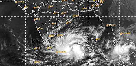
The low-pressure format which developed over the Bay of Bengal has intensified and transformed today (Tuesday, 6th December) into a strong depression zone!
Indian Meteorological Department (IMD) has estimated that this strong depression zone will transform into a cyclonic format by tomorrow (Wednesday, 7th December).
It is announced that due to this cyclonic format, there are prospects for heavy rain today and tomorrow (6th & 7th December) and very heavy rains the day after tomorrow (Thursday, 8th December).
The low-pressure zone which formed over the Bay of Bengal has intensified into a strong depression zone today (Tuesday, 6th December). This will further intensify into a cyclonic format and would drift towards Tamil Nadu and Puducherry.
The Chennai Regional Meteorological Centre has informed us that due to this cyclonic format, there are prospects for very heavy rains (Red Alert) in 13 districts including Chennai on 8th December!
The low-pressure zone which formed over the South Andaman Ocean and the adjacent coastal areas on Sunday morning (4th December), is drifting towards west and northwest!
This is likely to intensify into a strong depression zone by today evening (Tuesday, 6th December). It will then drift towards the west and northwest and intensify into a cyclonic format. On the 8th of December Morning (Thursday), this format may cross the coast via North Tamil Nadu, Puducherry and the adjacent South Andhra coastal areas.
As such, on 8th December, there are prospects for heavy to very heavy rains in a few places in the districts of Cuddalore, Villupuram, Chengalpattu, Kanchipuram, Thiruvallur, Chennai, Kallakkurichi, Ariyalur, Perambalur, Mayiladuthurai, Thanjavur, Thiruvarur, and Nagappattinam.
As there are strong prospects for cyclones to develop, fishermen have NOT ventured into the sea!