No. of views : (10409)
After 3rd November, Chennai to get more rains
Posted on: 30/Oct/2020 9:38:11 AM
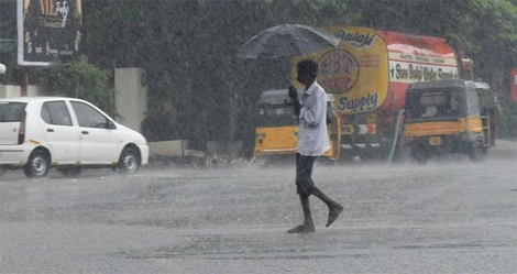
Chennai residents woke up to heavy rains on Thursday morning and this record breaking rain made lives difficult for many with water entering many houses. The streets were full of water and the traffic moved at a snail`s pace. Now, the Indian Meteorological Department or IMD has predicted more intermittent thunderstorms with heavy rains in Chennai on Friday.
According to some weather enthusiasts, Chennai would likely see brief near dry spells with isolated rains and this would be till 3rd November. Then monsoon would pick up speed and this would bring widespread rains in Chennai city, interior districts and coastal belts etc.
Nungambakkam recorded 13.34 cm of rain on Thursday morning and this was the highest 24 hour rainfall in the month of October since 18th October 2014 when there was 16.19cm rains. The IMD has predicted intermittent thunderstorms with moderate and heavy rainfall in some places. This would be in the next 24 hours.
On Thursday, the cyclonic circulation over south west Bay of Bengal of north TN coast was responsible for the intense rains in Chennai. This cyclonic circulation lies over north TN and south AP coast and neighbourhood.
After intense rainfall on Thursday, Nungambakkam station recorded 6.5cm excess rainfall in October. Point is that Nungambakkam registered 31.1cm rain since 1st October and Meenambakkam had a deficit of 96.2 percent and just 15.5 cm of rain was recorded in Meenambakkam in October.
It was mentioned by Chennai based weather blogger Mr. Pradeep john that Chennai could get regular early morning rains due to the easterly wave or an elongated area of low pressure moving from east to west. He hinted that the present cyclonic circulation could frizzle out. He was of the view that there could be daily rains in the Chennai city around 3rd of 4th November and this could be due to easterly waves or due to circulation.
Stronger weather systems due to Madden Julian Oscillation or MJO:
In the second half of November, a climate phenomenon termed MJO or Madden Julian Oscillation would be entering phase 2or 3 and this would act in favour of monsoon and would bring stronger weather systems.
It must be noted that MJO is an eastward moving disturbance of clouds, rainfall, winds and pressure that travels across the tropics and returns to the starting point in 30 to 60 days of time. As per the Skymet weather forecast, the intensity of the rains would be less.