No. of views : (2057)
Cyclone Warning for West Bengal and north Odisha coasts: IMD
Posted on: 19/May/2020 9:11:19 AM

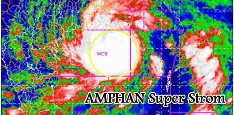
The Super Cyclonic Storm �AMPHAN� (pronounced as UM-PUN) over Westcentral and adjoining East-central Bay of Bengal moved north-northeastwards with a speed of 14 kmph during past 06 hours and lay centered at 0530 hrs IST of 19th May 2020 near latitude 15.6�N and longitude 86.7�E over Westcentral Bay of Bengal about 520 km nearly south of Paradip (Odisha), 670 km south-southwest of Digha (West Bengal) and 800 km south-southwest of Khepupara (Bangladesh).
It is very likely to weaken into an Extremely Severe Cyclonic Storm during the next 6 hours. It is very likely to move north-northeastwards across the northwest Bay of Bengal and cross West Bengal - Bangladesh coasts between Digha (West Bengal) and Hatiya Islands (Bangladesh) close to Sundarbans during the Afternoon / Evening of 20th May 2020 as a Very Severe Cyclonic Storm with maximum sustained wind speed of 155-165 kmph gusting to 180 kmph.
The super cyclone �AMPHAN� is now being continuously tracked by the Doppler Weather Radar (DWR) at Vishakhapatnam (Andhra Pradesh).
Heavy rainfall Warning:
Odisha: The light to moderate rainfall is very likely at most places of coastal Odisha with heavy rainfall at a few places over north coastal Odisha (Jagatsinghpur, Kendrapara, Jajpur, Balasore, Bhadrak & Mayurbhanj Districts) and isolated heavy to very heavy falls over Khordha & Puri districts on 19th May and isolated heavy rainfall over north Odisha (Bhadrak, Balasore, Mayurbhanj, Jajpur, Kendrapara and Keonjhar Districts) on 20th May 2020.
West Bengal: Coastal districts of Gangetic West Bengal (East Medinipur, South & North 24 Parganas) are likely to experience light to moderate rainfall at many places on 19th May. Rainfall at most places with heavy to very heavy falls at a few places & extremely heavy falls at isolated places likely over Gangetic West Bengal (east & west Medinipur, south & north 24 Parganas, Howrah, Hoogli, Kolkata and adjoining districts) on 20th May and isolated heavy rain over interior districts on 21st May 2020.
Sub-Himalayan West Bengal and Sikkim: Light to moderate rainfall at most places with heavy to very heavy falls at a few places over Malda & Dinajpur districts on 20th May and over most of the districts of Sub-Himalayan West Bengal & Sikkim on 21st May 2020.
Assam & Meghalaya: Light to moderate rainfall at most places with heavy to very heavy falls at a few places over the western districts of Assam & Meghalaya on 21st May.
Wind Warning
West Bengal & Odisha
- Squally wind speed reaching 55 to 65 kmph gusting to 75 kmph extend to along & off north Odisha coast from 19th afternoon and along and off West Bengal coast from 19th night.
- The wind speed will gradually increase becoming gale wind speed reaching 75 to 85 kmph gusting to 95 kmph from 20th morning along and off north Odisha (Jagatsinghpur, Kendrapara, Bhadrak, Balasore and Mayurbhanj districts) and West Bengal (east & west Medinipur, soututh & north 24 Parganas, Howrah, Hoogli, Kolkata Districts). It will gradually increase thereafter becoming 100 to 110 kmph gusting to 125 kmph along & off the above-mentioned districts of North Odisha.
- Gale wind speed reaching 155 to 165 kmph gusting to 180 kmph very likely along & off east Medinipur and north & south 24 Parganas districts and 110-120 kmph gusting to 130 kmph over Kolkata, Hoogli, Howrah, and West Medinipur Districts of West Bengal during the time of landfall (20th afternoon to night).
- Squally wind speed reaching 55-65 kmph gusting to 75 kmph likely to prevail over Puri, Khordha, Cuttack, Jajpur districts of Odisha during 20th May 2020.
Deep-Sea area
- Gale wind speed reaching 225-235 gusting to 255 kmph is prevailing over the west-central Bay of Bengal. It is likely to prevail over northern parts of central Bay of Bengal and adjoining North Bay of Bengal on 19th May.
- Gale wind speed reaching 180-190 gusting 210 kmph over north Bay of Bengal from 19th afternoon will gradually decrease becoming 165-175 kmph gusting to 195 kmph by 20th afternoon.
Sea condition: Sea condition is Phenomenal and is likely to continue for the next 12 hours over southern parts of Westcentral Bay of Bengal. It will become Phenomenal over northern parts of central Bay of Bengal and adjoining north Bay of Bengal on 19th May and over north Bay of Bengal on 20th May 2020.
Fishermen Warning
- The fishermen are advised not to venture into west-central and adjoining central parts of south Bay of Bengal during the next 24 hours, into the central Bay of Bengal and North Bay of Bengal during the 19th to 20th May 2020.
- Also, fishermen are advised not to venture into North Bay of Bengal along and off North Odisha, West Bengal and adjoining Bangladesh coasts till 20th May 2020.
Damage Expected and Action Suggested
West Bengal (East Medinipur, south & north 24 Parganas, Howrah, Hoogli, Kolkata districts)
Damage Expected:
- Extensive damage to all types of kutcha houses, some damage to old badly managed Pucca structures. Potential threat from flying objects.
- Extensive uprooting of communication and power poles.
- Disruption of rail/road links at several places.
- Extensive damage to standing crops, plantations, orchards.
- Blowing down of Palm and coconut trees.
- Uprooting of large bushy trees.
- Large boats and ships may get torn from their moorings.
Fishermen Warning & Action Suggested:
- Total suspension of fishing operations till 20th May 2020.
- Diversion or suspension of rail and road traffic.
- People in affected areas to remain indoors. Mobilize evacuation from Low lying areas.
- Movement in motorboats and small ships not advisable.
Odisha (Jagatsinghpur, Kendrdrapara, Bhadrak, Balasore, Jajpur & Mayurbhanj)
Damage Expected:
- Total destruction of thatched houses/ extensive damage to kutcha houses. Potential threat from flying objects.
- Bending/ uprooting of power and communication poles.
- Major damage to Kutcha and Pucca roads. Minor disruption of railways, overhead power lines and signaling systems.
- Widespread damage to standing crops, plantations, orchards, falling of green coconuts, and tearing of palm fronds. Blowing down of bushy trees like mango.
- Small boats, country crafts may get detached from moorings.
Fishermen Warning & Action Suggested:
- Total suspension of fishing operations till 20th May 2020.
- Diversion or suspension of rail and road traffic.
- People in affected areas to remain indoors.
- Movement in motorboats and small ships not advisable.
- Ananda Kumar Das, Scientist-E, RSMC, New Delhi


