No. of views : (13205)
Cyclone Gaja alert in Tamil Nadu (Tamilnadu weatherman updates)
Posted on: 11/Nov/2018 6:37:17 PM
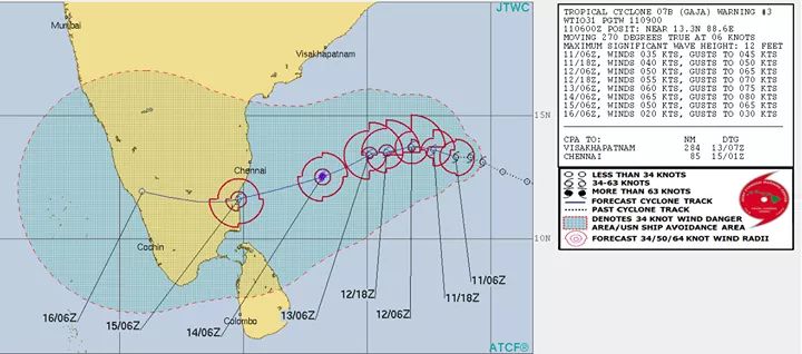
Cyclone Gaja to intensify in the next two days into Very Severe Cyclone and then take the fast WSW route and more likely to make landfall in and around Pondy or Cuddalore region on 15th November.
=========================
The mood change on NEM revival is on, thanks to Cyclone Gaja which will be rain-filled Cyclone with good SST and MJO in our basin, it will also sustain as cyclone till landfall. Lets see what we can expect from Gaja and what are the question which arises.
Where, when, how fast it is likely to move ?
-----------------------------------
It is now around 13.5 N latitude and expected to go little more up W-NW steered by the Pacific Ridge and then stalling happens with Steering Ridge change. The Arabian Ridge takes control and then comes the W-SW movement. pushing towards North Tamil Nadu coast between Nagai to Chennai somewhere around the Pondy or cuddalore region. Is this landfall fixed. The answer is no. Further, when it takes the W-SW route always the Cyclone moves too fast. The landfall will happen on 15th November.
How strong will Gaja get ?
-------------------------
Lets see the strongest cyclones to march towards TN / SL in last 40 years during NEM (Min 975 mb pressure)
1978 SriLanka Cyclone was 953 mb
2000 Cuddalore Cyclone was 959 mb
1996 Chennai Cyclone was 967 mb
1993 Karaikkal was 968 mb
2011 Thane was 969 mb
2000 SriLanka cyclone was 970 mb
1984 Cuddalore Cyclone was 973 mb
2016 Vardah was 975 mb
1984 Sriharikota Cyclone was 975 mb
Coming to Gaja it will not only intensify into a severe Cyclone but also into Very Severe Cyclone in open seas and then wind shear might affect it on nearing the North TN coast but still it will make landfall as a Cyclone with winds touching 100 km/hr. Only model which is peaking the landfall are the American GFS but it looks very unlikely to peak in strength with SW dip and also with moderate wind shear around. Anyway lets see how much pressure is seen in Gaja in the coming days.
Red Alert ah nambalama ?
-------------------
Yes. This time the red alert is associated with a Cyclone and Cyclone can dump 200 mm rainfall in 24 hours in the area where it crossing with ease, so no surprise in Red alert. The likely landfall area of around Pondy or Cuddalore area and the nearby places are likely to see extremely heavy rains. And when the Cyclone moves into interior Tamil Nadu and West Tamil Nadu to Arabian Sea. Nilgiris needs to be watched specially Coonoor, Ketti, Kodanad and Kothagiri regions. 15th November we can expect
How will Chennai be and what can Chennai expect if Cyclone goes to Cuddalore?
------------------------
The more the south the Cyclone goes the less the impact Chennai will see. Lets see how Chennai rains fared when Cyclone made landfall in Pondy or Cuddalore or Karaikkal or Nagai in last 25 years.
2015 November DD - landfall Pondy - Chennai 200 mm in a day
2013 Depression Wilma - Nagapattinam - Chennai 110 mm in 2 days
2012 Nilam - landfall mahabs - Chennai 120 mm in 2 days
2011 Thane - Cuddalore - Chennai 100 mm in a day
2008 Nisha - Karaikkakal - Chennai 400 mm in 4 days
2000 Cuddalore Cyclone - Chennai 100 mm in 2 days
1996 December Cyclone - Mahabs - Chennai 150 mm in 2 days
1993 Karaikkal Cyclone - Karaikkal - Chennai 170 mm in 2 days
1991 Karaikkal Cyclone - Karaikkal - Chennai 400 mm in 4 days
All the above cyclones moved from SW bay in WNW direction towards the TN coast expect the 1996 one which moved down like the current one from NW bay in WSW direction.
Assuming around Cuddalore as the landfall point, Chennai will see good rains from 14th night or by 15th morning and then after Cyclone moves into Arabian Sea on 16/17th Chennai can expect pull effect rains. So two-three days of rains. It will be windy on 15th too but nothing serious. I will be happy with 150 mm rainfall for Chennai in 2 days from this fast moving Cyclone.If there is slight change in landfall just north of Chennai then, this will change. We can bountiful rains from Gaje. Many almost lost hopes before Diwali, what ever we are getting we should be thankful.
Widespread rains to North TN
-------------------------
Extreme rains can be expected around landfall area and also in north western Tamil Nadu. Tamil Nadu coastal belt of Chennai, Kancheepuram, Tiruvallur, Villupuram, Nagai will also get good rains. Entire North interior tamil nadu districts Tirchy, Ariyalur, Villupuram,Perambalur, Karur, Salem, Erode, Tiruppur, Coimbaore, Nilgiris, Thiruvannamalai will also get rains. Kerala too will get one day of rains. South TN which got excess rains till date will see less rains from Gaja.
Fishermen
---------------
The sea will be very extreme from 12/13th November in North TN and South AP coast till the delta region. So dont go to seas till 16th Novemeber. So what happens in Arabian sea once it crosses TN and kerala on 16th Novmber. It will be very weak one in Arabian sea near Indian coast and even if it becomes cyclone again in Arabian Sea it will be very far away from Indian Coast. So one need not worry there.
Anymore twist on landfall location
--------------------
We have seen nature always pulls a surprise. Till last day before Cyclone Thane landfall, it was expected to make landfall close to Chennai and then on last day before landfall it dipped further down to Cuddalore. It was heart shattering moment for Cyclone lovers like me. I have read of few of the comments, For them i would like to state the following, we dont like to see devastation and see people suffer or enjoy fallen trees but to see one of the natural wonders (cyclone) is what we dream every day as weather bloggers. So this Gaja landfall somewhere around Cuddalore or Pondy might change too. But high probability of Cyclone crossing is around that area. Any change
North East monsoon 2018
---------------------
Tamil Nadu is in Deficit with -23% rains till date and Chennai -52% with Cyclone moving inland, the regions which has missed rains till date particularly interiors will surely benefit a lot. Though the cyclone in moving too fast it is going to dump huge rainfall in short period. Everyone remembers Vardah for winds but no one remembers it dumped 400 mm rains in few hours in OMR, Tambaram and Oragadam belt that day.
Anyththing after this Cyclone for TN
-----------------
Whether Gaje will again become cyclone in Arabian Sea or not needs to be watch. It is expected to move away from Indian coast. The good thing Gaja does is activate monsoon with one more trough of low moving near Sri Lanka. This easterly wave will give rains to TN coast / STN. We are just 15 days into monsoon so more low pressure are expected to form and develop in our Bay of Bengal. Lets hope Gaja given meaningful rains to parched areas of North TN and then start tracking the other ones later. Its again too early to call this year NEM. Tamil Nadu is sure to get above normal rains when season comes to close by December 31st.
Rumors
--------------
This is the ideal time for rumor mongers in FB, Whatsapp, youtube and TRP guys with creative mindset. Please dont forward or share them blindly in whatsapp or FB.